Applying Ecological Principles of Design for Restoring Brownfields: A Case Study in River Rouge, MI
Article information

Abstract
Background and objective
Failing industrial cities have left behind a legacy of social, economic, and environmental decline. The aftermath includes cities that have experienced departing residents, decaying infrastructure, and urban blight. Although there are many contributing factors to degradation, for cities such as Detroit, MI, much of its infrastructure has become vacant, and due to previous heavy industrial use, some of the lots have turned into brownfields. This research aims to create a design guideline for revitalizing industrial vacant lands or brownfields through the application of ecological design principles.
Methods
By adopting a case study approach, this research focuses on safely reconstructing the economic, social, and environmental health of communities by creating an ecological design matrix based on the landscape ecology principles of design; and applying those elements to the 80" Hot Mill company, located in River Rouge, MI, United States. Additionally, a landscape performance assessment was conducted to evaluate the benefits of the proposed planning and outcomes regarding environmental, social, and economic aspects.
Results
Following the creation of a master plan, the post-design metrics show positive environmental outputs such as the reduction of carbon sequestration, air pollution elements, waste from the site, and an increase in the retention of stormwater. The social impacts measured showed favorable outcomes which included visual quality, safety features, the addition of recreational and gathering spaces, as well as bike lanes and pedestrian walking paths. Economically, improvements have been seen in stormwater maintenance costs and energy savings.
Conclusion
The findings from this research aim to help future designers and planners in implementing ecological design principles in order to optimize the restoration processes of brownfields and vacant lands.
Introduction
During the late 1950s, industrial cities experienced economic failures due to companies leaving that led to a phenomenon known as shrinkage (Wang et al., 2020). The abrupt exit of businesses had a domino effect, socially through a decrease in population, economically through a weakened workforce and tax base, and environmentally with the rise of vacancies throughout the city. As stated by Newman et al. (2016), urban vacancies are caused by the uneven expansion of the population, since residents tend to move further away from the core of the city, leaving behind much of the existing infrastructure. There is a natural social cause for urban vacancies taking place, some due to job losses and economic instability. However, these cities once had booming economies, and historically, most were part of what is known as the 'Rust Belt'. The City of Detroit, Michigan, USA is a prime example of a shrinking city.
There have been past unsuccessful attempts to prevent urban vacancies. Any city experiencing high rates of vacancy, simultaneously undergoes financial difficulties; fewer citizens mean there is no excess tax revenue for revitalization of vacant lots. Many of the now vacant cities are fully equipped to handle high population densities-their infrastructure remained intact (Gu et al., 2019). Generally, brownfields contribute to increasing environmental, social, and economic challenges. The greatest risk factor associated with brownfields is the negative impact they pose to human health (Zhong and Popovich, 2022). Historically, most polluted sites were previously used as dumping grounds or as old factories. The contaminants are deep within the soil particles and have compromised the air quality.
Recently, the idea of sustainable urbanism gained popularity, where the existing framework of a city is retrofitted to current standards. One way of promoting sustainable urbanism is through revitalizing vacant lots or brownfields. Ultimately, the goal is to minimize any environmental or ecological damage caused by new and unnecessary construction on the site. One major consideration for rehabilitating brownfields is applying ecological restoration approaches, which is defined as the reconstruction of a degraded ecosystem (Ghosh et al., 2021). In these processes, attempts are made to restore decayed soil. Ghosh et al., (2021) has shown that certain plant species, especially ornamental grasses, are able to restore much of the soil nutrition to its original state. The restoration is due to successful soil microbial processes which involve carbon as the main element to maintaining soil health. The different pools that involve soil organic carbon consist of water-soluble C (SWC) and permanganate oxidizable C (KMnO4-C) to help identify the early stages of successful eco-restoration. It has been found that when soil enzymes interact with carbon, it is a great assessment to the degree which the restoration will be successful (Ghosh et al., 2021). Although the soil restoration process is extensive, it positively impacts plant health and improves air quality.
Most previous restoration efforts using ecological planning principles have only been implemented at small scales. Shafer (1994) introduces the concept that parks are ecologically incomplete entities; they were not planned to serve the needs of the ecological community and are designed based on human needs. Shafer discusses issues including fragmentation, loss of species populations, and encroachment, which are all linked to site boundaries. There is mention of how these environmental issues are multi-dimensional, meaning that some of the issues that species face is due to both social and economic concerns. Subsequently, he suggests that soft edges, buffer zones, and creating corridors/greenways would help connect species (Shafer, 1994).
An effort to understand the complex relationship between species' health and the built environment was made by Diamond. The focus of his research was on species behavior following disruptive human activities. A few similar ecological principles to the ones suggested by Shafer were mentioned such as size, migration, and connectivity, but the focus was shifted more toward prevention than restoration. Diamond argues that larger reserves are better because species can be sustained in a healthy manner and will have lower extinction rates (Diamond, 1975). The solutions offered serve as the building blocks to the ecological planning principles that many landscape architects and planners are using to guide their designs.
Previous research has focused on smaller-scale projects such as parking lots, vacant/abandoned lots, and introduced ecological design concept with hypothetical conditions. However, it is crucial to give equal consideration to larger scale abandoned sites. In the case of the Metro Detroit area, the entire city matrix has suffered from deterioration and fragmentation due to human activities and changes in land use. This type of fragmentation creates isolated vacant patches that hinder seamless connections between communities, serve no ecological purposes, and impede on economic development. The aim of this research is to develop design guidelines for revitalizing industrial vacant lands or brownfields using ecological design principles. Through literature reviews and case studies, a comprehensive set of guidelines was created for the transformation of an abandoned steel factory. A landscape performance assessment was conducted to evaluate the environmental, social, and economic benefits of the proposed planning and outcomes.
Research Methods
Study area
The City of River Rouge, MI, an industrial suburb of Detroit, was selected as the study location; it served as an integral part of Metro Detroit's automotive industry since it focused on manufacturing iron and steel; it is an example of a prosperous city that turned sour. The first steel company that was established in the River Rouge neighborhood was Zug Island, which was initially designed to be an industrial dumping site. However, it became a steel manufacturing plant and experienced immense growth leading to the establishment of the Great Lakes Steel Company and the 80" Hot Mill. These three companies, being connected by railroad, operated together for over 100 years, but with the deindustrialization of the automobile, between 1940–2003, many employees were laid off.
The research location, 80" Hot Mill Steel Company, is nestled between the City of Ecorse and the City of Detroit with a population of 7,224 (United States Census Bureau, 2020). Additionally, the population has a lower percentage of high school graduates compared to surrounding cities with an average of 80% for River Rouge and 82% for Detroit. When comparing educational data for college graduates, the statistics are even lower with 9% of residents of River Rouge having a college degree in comparison to 16% in Detroit and 11% in Ecorse. The demographic data also depicts that the residents of River Rouge are predominantly African American (49%) and White (42%). Economically, River Rouge has the lowest median income of $23,000 when compared to Ecorse or Detroit, which both have an average of $33,000 (United States Census Bureau, 2020).
The 80" Hot Mill Steel Company occupies approximately 260 acres, with warehouse buildings covering 27.92 acres and averaging 45 meters in height. Accessibility to the site is challenging, given the limited and deteriorated entryways. The extensive concrete coverage and the flatness of the site contribute to severe flooding issues. The site's topography is predominantly flat, complemented by clay-based soils and lacking significant vegetation or greenery. Despite the existing environmental challenges, the site has great potential for water front design, offering opportunities in stormwater management, providing social benefits for the community restoring wildlife habitats, and implementing sustainable practices.
Ecological design matrix
As part of the site recommendation, a design matrix has been developed, drawing upon landscape ecology principles outlined in the previous studies (Dramstad et al., 1996; Kim et al., 2014). Based on literature review and the findings from the site analysis, this study developed a design matrix focusing on four types of ecological design principles: fragmentation, size, edge, and corridor (Table 1). The design considerations are based on the selected ecological design principles and serve as the foundation; establishing the design goals and elements to be incorporated into the final design proposal.

Ecological design matrix
For this study, the principles of ecological design were employed to formulate site-based goals. Through the incorporation of program elements like an elevated boardwalk, the habitat of species remains unfragmented, ensuring their health while facilitating movement for site visitors. The introduction of floating islands would mitigate issues of species isolation and patch size by creating diverse sizes of floating wetlands. This approach involves the use of varied plant species to establish a gentle and undulating surface conducive to the thriving of species habitats. Furthermore, the design includes a corridor connecting the Detroit River to the site, enabling species to migrate across various habitats and enhancing overall habitat quality.
Landscape performance assessment
Landscape performance research has become widely recognized and adopted within the fields of planning and landscape architecture due to its significant impact (Shevela et al., 2022; Yang et al., 2020). Landscape performance research offers valuable tools and methodologies that researchers and professionals utilize to design public spaces that are not only aesthetically pleasing but also environmentally, socially, and economically sustainable. It involves quantifying and evaluating the environmental, social, and economic benefits of landscape architecture projects through a metric-driven approach. As part of this study, a set of metrics has been proposed to assess the effectiveness and success of the proposed design. These metrics are organized into three categories: environmental, social, and economic. By employing these measures, the study aims to quantify and analyze the project's performance in terms of its environmental impact, social benefits, and economic outcomes (Table 2). Through incorporating landscape performance research metrics, this research strives to provide evidence-based insights and data-driven assessments that can guide decision-making processes and enhance the overall quality and performance of design or planning projects.

The selected landscape performance metrics and methods
Measuring environmental benefits
The environmental benefit metrics of (1) carbon sequestration, (2) stormwater retention, (3) removal of air pollution, and (4) removal of contaminated soil was measured. These variables were further categorized into sub-categories of each metric as shown in Table 2 below. The Pathfinder carbon sequestration model, was adopted to predict the number of years until the site would be carbon positive, meaning that the emissions from the site are equal to 0, or within 353 years. The EPA Stormwater Calculator was used to calculate retention and detention metrics. Similarly, a calculation of acres of land coverage was inputted into the software as well as the low impact development (LID) strategies. Through using the iTree planting calculator, the estimated air pollution was measured in tons/per year. With the intent of long-term sustainability and ecological safety, only native trees to Michigan were planted. The Waste Management Calculator was used to measure how many tons of waste was removed from the brownfield, this was obtained by converting square feet to cubic feet, where an average depth of 4" was assumed for both baseline and design scenarios and inputting those values into the calculator. Once the total areas were measured for both the steel train tracks and the concrete to be recycled, the values were inputted into the Waste Management Calculator, where the estimated steel and concrete tons were calculated, and the results showed the emissions created.
Measuring social benefits
For measuring social benefits, the following variables were measured: (1) visual quality, (2) safety, (3) recreational space, (4) gathering space, and (5) bikeability. During the design process, the focus was placed on providing a community event. When measuring the spaces, outdoor recreational areas were separated from indoor ones as both provide a different social benefit. The three types of safety features were: lighting, sidewalks, and crosswalks. Adding protected bike lanes proves to bring both safety and recreational value to its users. Visual quality was measured using the Floristic Quality Index (FQI), developed (Universal Floristic Quality Assessment Calculator, 2015).
Measuring economic benefits
Economic benefit measures were intended to be an extension of the environmental benefits by showing the monetary savings of an ecological design. The following variables were measured (1) stormwater retention costs and (2) air pollution savings. A calculator tool provided by Center for Neighborhood Technology Green values was used to estimate the annual savings in terms of maintenance costs for the site. The values were obtained by inputting information about the site cover and the LID controls. Using the iTree planting model, the tree species proposed were placed on the site and the calculator was able to model the pollution savings.
Results and Discussion
Design programs and master plan
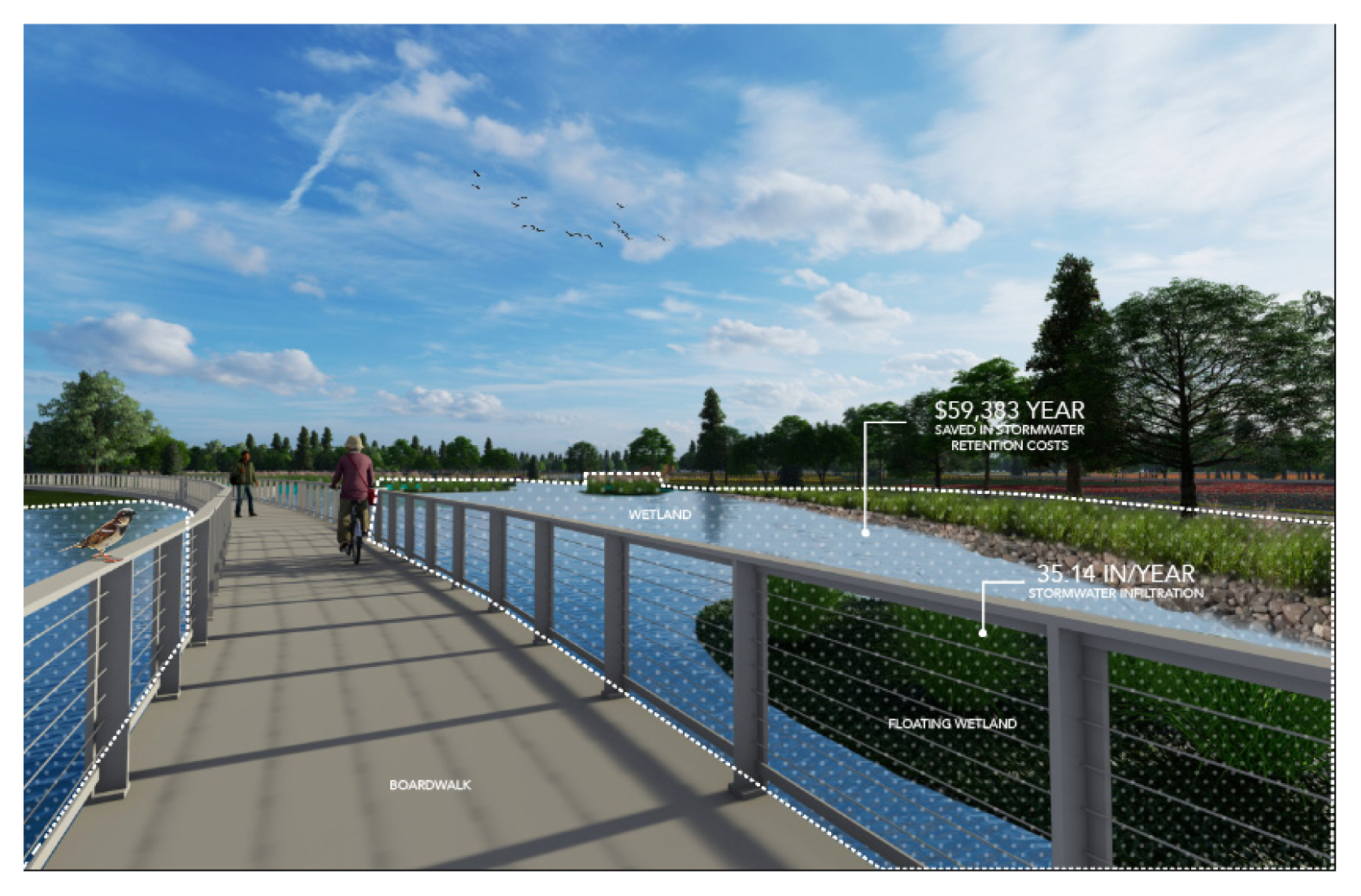
Ecological planning and design principles were applied in the master plan, where four intents were put into practice, such as varying elements of floating wetlands, vegetation, and soft and undulating plant edges (Fig. 1). The strategies applied aim to create a diverse and inclusive environment for species, provide various recreational opportunities, enhance species equality and diversity, and measure the monetary savings of an ecological design. As visitors enter from Great Lakes Ave, they are welcomed by a visitor center with interpretive displays, programs, services, and information. The road connecting to and from the site is intended to be one-way, enhancing the safety of visitors. Connected to the visitor center and across the entry road, there is designated flexible space, meant for versatile use of outdoor activities. As part of the social improvements, the existing warehouse is to be repurposed into a center that would hold gathering spaces and educational classes. Similarly, the Community Park serves a multi-use purpose, acting as both an open space for flexible use and an outdoor amphitheater to host events. Thought out the site, bioswales are used as both a safety feature and a stormwater mitigation strategy.

Master plan.
One of the ecological planning components is the meadow, whose purpose is to improve soil health, promote species diversity, and bring social benefits to visitors. Additionally, this helps reduce the fragmentation that animal species experience with extensive infrastructure development. The large patch size allows for an increase in habitat health, species connectivity, and mobility. A wetland wraps around the community park and features floating islands for species diversity and health. The soft undulating vegetative edges decrease the extent of species isolation by providing a buffer zone where species are able to transition smoothly from one habitat to another. Similarly, the Detroit River was invited into the site through a channel; this design implementation provides a corridor for species to migrate. The elevated boardwalk prevents fragmentation of the site by allowing species habitat to remain intact and sustaining human use.
One of the strategies employed was the integration of floating wetlands (islands), intending to help with species restoration, habitat creation, and species diversity and improve ecological functioning (Fig. 2). Vegetation played a crucial role in design, and with careful consideration and a variety of flora was incorporated to provide suitable habitats species. To enhance the ecological value of the site, soft and undulating plant edges were introduced. This ecological planning strategy is intended to help promote species diversity and habitat richness while serving as transition zones by facilitating movement and creating opportunities for interactions.
River promenade.
Design impact: Landscape performance assessment
Based on the final design proposal, landscape performance research has been employed to evaluate the benefits of the design and assess impacts. The assessment involves comparing the existing environmental conditions of the site, which were measured and used as a baseline, with the anticipated outcomes and benefits of the proposed solution.
Environmental Benefits
The advantages of the proposed plan can be seen through the percentage of positive change for each category, as shown in Table 3. Carbon sequestration and stormwater measures presented significant change, with the total plant sequestration post-design improving by 203.40%. Much carbon emissions and sequestration were offset by the 17,579.91 m2 of wetlands, 104,524.62 m2 of perennials, and an additional 1,709.68 m2 of stormwater plantings. The bioswale plant material also counts as a LID treatment for flooding, and it is able to infiltrate an additional 71.76 cm of rainwater per year than the existing infrastructure can. The proposed LID treatments enable to infiltrate the average annual rainfall up to 89.26 cm per year. The proposed plan includes 500 Michigan native trees to be planted, where an estimated 22.08 tons of air pollution would be removed per year. Due to a lack of data availability, the baseline scenario for this metric was imputed as zero, and therefore the percent change is undetermined. The estimated amount of removed contaminated soil was estimated approximately 67,737 tons, given the proposed plan.

Environmental benefits calculations
Social Benefits
The calculations made regarding the new social and recreational opportunities, as well as the safety attributes, are based on the suggested renovations for the study area. Since the previous use of the site was industrial, these physical and social activities did not exist, and the baseline scenario has been set to zero. As seen in Table 4, the visual quality, which was measured by the FQI at 25.80 post-design, in terms of ecological integrity, is high quality. The new safety features added are 100 lighting features, 13,651.44 m2 square meters of sidewalks, and 8 new crosswalks. Recreational and gathering spaces were added between the community center and outdoor amphitheater, and this allocated space totaled 4,784.77 m2. Lastly, bike lanes were added for an additional 5,608 m.

Social benefits calculations
Economic Benefits
The economic analysis focused on gathering data on cost savings for stormwater retention costs and pollution (Table 5). The threshold for stormwater was based on the existing vegetation and annual costs without LID. The data shows that including LID, the overall annual cost would be lowered by nearly 25% and the life-cycle cost would decrease by 61%. These annual savings for pollution were estimated using iTree, but there is no value for the base state of the site. With the suggested improvements, $14,298 would be saved per year.

Economic benefits calculations
The fall of industrial cities has left many cities in disorganized chaos. With the loss of residents and tax revenue, it has become a challenge to sustain lively communities. The potential of vacant lands, specifically brownfields, is unrecognized in the community planning process (Kim et al., 2015). The intent of this research was to help determine the ecological process of restoring brownfields. Secondly, it aims to be a tool for professionals to further facilitate learning by using a quantitative research method approach. The blended use of sustainability analysis, case study, and landscape performance assessment offered a rigorous perspective of what revitalization efforts could entail. Through planning, revitalization, and research design considerations, the decision-making process will be tailored to further reinforce and support the economic development, social aspects, and environmental benefits that extend beyond the use of the site.
Conclusion
Urban spaces are designed with user intent in mind, meaning the community utilization of space is given much more weight compared to the biodiversity that is being affected in the process of re-design. The success of a design is based on the extent of site-related factors that were considered. Restoring vacant lands is critical to the future of the sustainability of the land, and the health of communities (Nassauer, J., and Raskin, J., 2014). This research explored various approaches to revitalize sites to their fullest and healthiest potential. As with all research, there were limitations, including data availability and safety concerns regarding site accessibility. The proposed design was evaluated using landscape performance metrics, and the percentage change for each metric was calculated to demonstrate a positive correlation between design intent and outcome. Further research could be strengthened by emphasizing community involvement in the design process and creating a comprehensive site inventory to enhance decision-making in design.
For this study, the success of a design is based on the extent of site-related factors that were considered. Restoring vacant lands is critical to the future sustainability of the land and the health of communities (Nassauer and Raskin, 2014; Yang et al., 2020). With the proposed redevelopment of the 80" Hot Mill Company, new amenities for residents were added that will positively impact community health and wellness. Economically, the new amenities will generate revenue for the city of River Rouge, MI, enticing more residents to move to the area and bring life back to what used to be an industrial city. The environmental restoration benefits can be seen through diverse species coming back and reclaiming their habitats, and plants becoming established and growing throughout the site, leading to pollution and carbon sequestration being offset by a successful plant palette.
This research would be beneficial to a range of professionals, including environmental designers, ecologists, urban planners, and landscape architects. The recommendations suggested by this study would assist in developing ecologically safe designs, taking into account the specific context and previous land use conditions. Through incorporating the findings and recommendations of this research, professionals can contribute to the creation of environmentally sustainable and safe designs that promote the well-being of both the natural environment and the communities that inhabit these spaces. By considering these ecological design and planning principles, restoration efforts can help integrate fragmented landscapes, enhance species connectivity, and promote the long-term sustainability of restored areas.