


Identification of High-Priority Wild Boar (Sus scrofa) Control Areas by Predicting Potential Habitat and Crop Damage
-
KimHo Gul, SongWonkyong, ParkChan, SongYoungeun, ChoSoo-Hyun, OhHyun Kyung, KimWheemoon

- Received July 28, 2023; Revised November 27, 2023; Accepted January 15, 2024;
- ABSTRACT
-
- Background and objective: The wild boar (Sus scrofa) is a highly mobile, fertile, clever, stealthy, and adaptable animal. It is distributed around the world and inhabits a fairly wide range of habitats, which results in frequent friction and conflict with humans. Disturbances caused by wild boars, such as crop damage on agricultural land and the spread of African swine fever, has recently been increasing in Korea, making it necessary to confirm the habitat range of wild boars and to predict the possibility of future crop damage.
- Methods: The locations of Gapyeong-gun, Namyangju-si, Yangpyeong-gun, and Gwangju-si in Gyeonggi-do, where crop damage caused by wild boars is confirmed to be serious, were selected as the study area. Data from 2nd to 4th National Natural Environment Surveys (covering three periods of respectively 8, 8, and 5 years) were used to analyze the continuity of potential boar habitat, and data from point samples of crop damage were used to identify areas with a high probability of future crop damage. The MaxEnt model was used to analyze potential habitats and crop-damage areas based on 15 environmental variables selected through literature research.
- Results: The average area under the receiver operating curve (AUC) of the resulting potential habitat models for the three survey periods was 0.644, and the AUC of the crop damage prediction model was relatively high at 0.850. The resulting key crop-damage priority management areas were Seorak-myeon, Gapyeong-gun; Sudong-myeon, Namyangju-si; Joan-myeon, Namyangju-si; Sang-myeon and Gapyeong-gun; Gapyeong-eup, Gapyeong-gun.
- Conclusion: This study illustrates changes in the spatial distribution of wild boars in Korea based on time-series survey records from 1997 to 2018. These findings are expected to be useful as reliable reference data for setting priorities when establishing future measures to prevent crop damage, such as managing the number of wild boars in Gyeonggi-do.
- Introduction
- Introduction
The wild boar (Sus scrofa) is a highly mobile animal of high fertility, intelligence, and secretiveness. It can thrive virtually anywhere, displaying amazing adaptability (Allwin et al., 2016), and is thus easily able to adapt to various habitat types and inhabit wide areas (Allwin et al., 2015; Takashi et al., 2019). This has inevitably led to friction and conflict with humans. The wild boar is diurnal but has more recently adapted to a nocturnal lifestyle, making it difficult to monitor its behavior (Pei, 2006).In Korea, damage caused by wild boars has recently been increasing. This includes crop damage in farmland and the spreading of African swine fever (ASF) (Yoo, 2018). ASF is believed to have spread into Russia, China, and North Korea in 2019 and extended along the border areas of Gyeonggi Province (KNPS, 2022). It has been confirmed that the average population density of wild boars in Gyeonggi-do national parks is higher than in mountainous national parks, and preemptive responses are in progress to delay and block infectious diseases borne by the species from moving south (KNPS, 2022). To prevent damage by wild boars, countermeasures such as capture and hunting using firearms and the installation of fences to restrict movement are being implemented (NIBR, 2016). However, due to the species’ high fertility and mobility, the effectiveness of hunting is temporary, and it is impossible to completely prevent the spread of wild boars, as sooner or later they will find a fault in the fencing and escape to another area.The increase in boar populations and the number of damage incidents can be largely explained by two factors. First, it is known that populations have increased significantly due to a decrease in apex predators, ongoing climate warming, and the expansion of suitable forest habitat (Claudia et al., 2006; Choi, 2008). Second, even in areas were populations have not increased significantly, habitat destruction may lead to increased occurrence frequency in residential and farming areas, as in in some areas of Gyeonggi-do (Takashi et al., 2019; GRI, 2020).Some related research includes the study of Choi et al. (2006), who analyzed the activity range of wild boars on Mt. Jiri, and that of Lee and Lee (2014), who conducted dissections of captured wild boars to analyze their food habits. The National Institute of Biological Resources (NIBR) is currently identifying the density and population of wild boars in the course of a nationwide wildlife survey in preparation of establishing a management plan (NIBR, 2017).Studies on the habitat range, food characteristics, and habitat density of wild boars are continuously being conducted, but research into changes in potential habitat availability is currently limited. In addition, although studies of damage caused by wild boars have been conducted recently, most of these remain at the level of summary and statistical analysis (Kim et al., 2014; Yoo, 2018). Choi (2008) conducted a GIS-based study on crop damage by wild animals and relevant countermeasures. However, efforts to spatially predict the potential for crop damage or to derive priority management areas in connection with potential habitat distribution remain insufficient.To address this knowledge gap, the present study aimed to identify areas in need of damage prevention measures against wild boars, focusing on Gapyeong-gun, Namyangju-si, Yangpyeong-gun, and Gwangju-si in Gyeonggi-do, as these are areas where serious crop damage caused by wild boars has been confirmed. Because resources for wild boar damage management are limited, preferential investment of manpower and resources in priority management areas where serious damage is expected is essential for effective management.This study accomplished three specific goals. First, wild boar habitat throughout the species’ range in Korea was analyzed using data from the 2nd, 3rd, and 4th National Survey of Natural Environments, and areas where the potential habitat was continuously maintained were identified at the eup, myeon, and dong level. Second, based on existing crop damage information, a damage prediction map was created to identify areas where future damage can be expected. Third, priority management areas were derived based on the sustainability of potential habitats and predictions of crop damage (Fig. 1). The results of this study are expected to be used as data to support decision-making by helping to identify high-priority areas when establishing damage prevention measures (such as population management) in Gyeonggi-do.
- Research Methods
- Research Methods
- Study site
- Study site
The spatial scope of this study was selected as Gapyeong-gun, Namyangju-si, Yangpyeong-gun, and Gwangju-si in Gyeonggi-do (Fig. 2). Administrative districts in Korea are classified based on the number of permanent residents. In general, if the population is less than 50,000, ‘-gun’ is added to the name of the administrative district, and if the population is greater, ‘-si’ is added. Additionally, ‘-si’ or ‘-gun’ are classified into lower administrative districts of ‘-eup’, ‘-myeon’, and ‘-dong’ and are classified according to whether they are urbanized. National Natural Environment Survey data show that wild boars have been continuously established in this target area and that resultant crop damage has steadily occurred. Regarding the prevention of the spread of ASF, Gapyeong-gun is considered a key countermeasure area, and Namyangju-si and Yangpyeong-gun are classified as prevention areas.- Environmental variables
- Environmental variables
Candidates for environmental variables were selected based on previous studies of domestic and foreign wild boar habitat, feeding characteristics, and behavioral characteristics (Table 1). Environmental variables were divided into three types: land cover, forest, and topography and geology (Table 2). The land cover variables consisted of “distance from residential/industrial/commercial areas”, “distance from roads”, “distance from rice fields”, “distance from fields”, “distance from orchards”, “distance from streams”, “distance from bare ground”, and “distance from hiking trails.” Forest variables consisted of “forest and grassland type”, “forest density”, “presence of oak”, and “age level.” Terrain and geological variables consisted of “slope”, “aspect”, and “soil drainage grade.”The points at which wild boars were identified in the 2nd, 3rd, and 4th National Natural Environment Surveys were combined with land cover data recorded as close as possible to the period. The Ministry of Environment of the Republic of Korea conducts a nationwide natural environment survey every five years. The first survey was carried out from 1986 to 1990, the second survey from 1997 to 2005, the third from 2006 to 2013, and the fourth survey from 2014 to 2018. The fifth survey is currently underway in 2023. The land cover map for 2000 was used for the 2nd survey, the map for 2010 for the 3rd survey, and the map for 2017 for the 4th survey. The environmental variables selected were those that are not expected to change significantly over time (such as altitude, slope, and bio-climate), and where time-series data had not been established, data from the same period were applied. Variables were categorized as either continuous or categorical. A 30 × 30 m spatial grid was used for analysis in consideration of the resolution of the obtainable environmental spatial information. To prevent bias arising from multicollinearity, pairwise correlation analyses between environmental variables were performed, and variables with a correlation coefficient of ≥ 0.6 were excluded from the analysis.- Establishment of wild boar occurrence points and crop damage
- Establishment of wild boar occurrence points and crop damage
To integrate the wild boar occurrence data, the points near the target areas at which wild boars had been recorded were extracted from the data of the 2nd to 4th National Natural Environment Surveys. In total, 64 points were extracted from the 2nd survey, 250 points from the 3rd survey, and 240 points from the 4th survey (Fig. 2). Information on the location of crop damage was extracted from the addresses of damaged areas surveyed in Namyangju, Yangpyeong, and Gwangju, Gyeonggi-do, and points not located in areas designated as “farmland” in the land cover data were omitted. Among a total of 1,998 damaged areas, 595 addresses corresponding to farmland were extracted and used for analysis.- Species distribution model
- Species distribution model
A MaxEnt (Maximum Entropy) model was used as a spatial distribution model to predict potential wild boar habitat and crop damage probability. MaxEnt models have the advantage of requiring only occurrence point data-in this study, occurrence of wild boars and occurrence of crop damage-as the dependent variable (Aiding et al., 2017); they are therefore suitable for modelling survey data that lack absence information. It should be noted that in contrast to boar absence data, it is difficult to arbitrarily construct accurate information on the absence of crop damage. However, the MaxEnt model was deemed suitable for this study because its reliability has already been demonstrated in many previous studies (Zhang et al., 2018). We used MaxEnt version 3.4.1 software to create probability maps of wild boar and crop damage occurrence.MaxEnt makes the basic assumption that species occurrence sites are consistently surveyed either globally or randomly (Kramer-Schadt et al., 2013). However, if the number of actual species occurrences is small or the investigator’s research efforts are spatially biased, model results may be subject to over- or underfitting (Yackulic et al., 2013). In this study, we therefore used the kde2d function of the R package MASS, which provides a two-dimensional kernel density estimate based on the coordinates of species occurrence points, to create a bias layer and apply it to the model to prevent overfitting of the output.To evaluate the reliability of the model, the Area Under Curve (AUC) value of the Receiver Operating Characteristic (ROC) curve was used. When deriving the MaxEnt model, 5-fold cross-validation was performed to estiamte for the uncertainty in the model that may occur during one run. A value of “10 percentile training presence” was applied as the threshold required to derive binomial maps from the probability maps.The crop damage prediction model used the commonly employed “equal interval approach” to grade damage by region into five categories (0–0.2, unsuitable; 0.2–0.4, low suitability; 0.4–0.6, general; 0.6–0.8, moderate suitability; and 0.8–1, high suitability) (Li et al., 2020; Ab Lah et al., 2021).
- Results and Discussion
- Results and Discussion
- Environment variable selection
- Environment variable selection
Prior to selecting environmental variables, the model for each period was test-run to confirm the contribution of each environmental variable to the model. In order to prevent problems with model fit due to multicollinearity, pairwise correlation analyses between environmental variables were performed, and variables with a correlation coefficient of 0.6 or higher were excluded, taking into consideration their relative performance in the test runs. Among highly correlated variables, “distance from bare land” had a lower contribution than “distance from field” or “distance from residential/industrial/commercial area” and was therefore excluded. Considering the behavioral characteristics of wild boars, “age class” rather than “density” was removed from the forest variables. The variables “distance from field”, “distance from road”, and “distance from residential/industrial/commercial area” were judged important and used in the final model because they had a high contribution to model fit in all survey periods during the test runs. In the crop damage prediction model, “density of forest”, “forest type” and “oak tree presence” were excluded from the forest-related variables because they were found to have little explanatory power (Table 3).- Potential wild boar habitat models
- Potential wild boar habitat models
Models for the 2nd, 3rd, and 4th National Natural Environment Survey had AUC values of respectively 0.634, 0.616, and 0.682. Swets (1988) assessed AUC values of 0.5–0.6 as “bad”, 0.6–0.7 as “fair”, 0.7–0.8 as “good”, and > 0.8 as “very good”, while Carter et al. (2016) used evaluations of 0.51–0.69 as “poor”, 0.7–0.79 as “fair”, 0.8–0.89 as “good”, and 0.9–1.0 as “excellent.” Under both evaluation schemes, models for all three survey periods showed mediocre reliability. The critical value used for the production of the binomial maps was the average value of five replicate model runs: 0.444 for the 2nd survey, 0.348 in the 3rd survey, and 0.347 in the 4th survey (Fig. 3).The contribution of variables to the potential wild boar habitat models by period is shown in Table 4. In the model based on the 2nd survey, the contributions of ““type of forest and grassland”, “distance from river”, “soil drainage grade”, “distance from paddy field”, and “distance from farm field” were high. In the 3rd survey-based model, “distance from river”, “distance from trail”, and “distance from road” showed high contributions. In the 4th survey- based model, the contributions of “distance from road”, “distance from trail”, “distance from farm”, and “forest and grassland type” were high. Variables with high contributions in all three periods were “distance from river” and “distance from farm”, and variables with high contributions in two out of the three periods were “type of forest and grassland”, “distance from trail”, and “distance from road.”Habitat preference characteristics of wild boars distributed in the Gyeonggi-do region were estimated based on the contribution of variables in the potential habitat model for each period. In the 2nd period (1997 to 2005), wild boars preferred areas with natural grasslands and mixed forests, and within 200 m of rivers. In the following 3rd period (2006 to 2013), preference changed to areas within 1–2 km of rivers, close to trails, and 5 km away from roads. In the recent 4th period (2014 to 2018), boars preferred areas more than 8 km away from roads and trails. This indicates that in the past, wild boars were mainly distributed in natural environments such as mixed forests, grasslands, and rivers, but later became more closely habituated to humans and their areas of activity.- Crop damage prediction model
- Crop damage prediction model
The AUC value of the crop damage prediction model was 0.850, showing very high reliability. The possibility of damage to crops was classified into five equally spaced grades, and a map was produced (Fig. 4). Areas with high damage potential were widely distributed in all four local governments within the target area. Among these, Yangpyeonggun had the widest distribution of areas with high damage potential, and Yeoju-si and Icheon-si, Gyeonggi-do, which are directly south of Yangpyeong-gun, also showed extensive high-potential areas. The variable that showed the highest contribution in the crop damage prediction model was “distance from the farm”. “Soil drainage class”, “distance from residential/industrial/commercial areas” and “distance from orchard” also had relatively high contributions.The characteristics of areas where crop damage from wild boar activity is expected were identified based on AUC values. With respect to variables related to land cover, the probability of damage was high in areas located at a slight to moderate distance (10–200 m) from residential/commercial/industrial areas, and similarly in areas located 10–100 m from a road. Damage probability was high within 200 m of rice fields and in close proximity (within 30 m) to other fields. Additionally, a high probability of damage was found within 600 m of orchards and within 500 m of rivers. In contrast, damage probability was high in areas located 1,000–3,000 m from trails. With respect to variables related to topography and geography, gentler slopes were correlated with higher probability of damage, as were southwestern and western slopes. In addition, the soil drainage grade was uniformly high in areas with low to high damage levels.- Continuity and change of potential habitat by region
- Continuity and change of potential habitat by region
The size of the area identified as potential wild boar habitat in all three models was calculated for each administrative district within the modelled area. Gapyeong-gun had the greatest total habitat area, followed in descending order by Yangpyeong-gun, Namyangju-si, and Gwangju-si (Fig. 5, Table 5). It was confirmed that calculating the ratio of the habitat area to the total administrative district area yielded the same ranking.Based on the size of the areas identified as potential habitats in all three models, the top 10 regions with the greatest potential habitat were, in descending order: Bukmyeon, Gapyeong-gun; Gapyeong-eup, Gapyeong-gun; Jojong-myeon, Gapyeong-gun; Sang-meyon, Gapyeong-gun; Namjong-myeon, Gwangju-si; Sudong-myeon, Namyangju-si; Danwol-myeon, Yangpyeong-gun; Seorak-myeon, Gapyeonggun; Yongmun-myeon, Yangpyeong-gun and Joan-myeon, Namyangju-si.Wild boar population density data from 2011, 2015, 2017, and 2019 (NIBR, 2011, 2015, 2017, 2019) were corroborated by model results for the temporally close 3rd (2006–2013) and 4th (2014–2018) surveys. In Yangpyeong-gun, population densities tended to increase and then decrease over the 2011–2019 period, but wild boars showed a continuous presence in the area. In Gapyeong-gun, population densities showed a tendency to rapidly increase in 2019 after maintaining steady levels during the 2011–2017 period. The population densities of Namyangju-si maintained a rapidly increasing trend starting in 2015, while Gwangju-si showed low densities during the 2011–2017 period followed by rapidly increasing densities in 2019 (Table 6).The wildlife fact-finding survey of the NIBR uses different survey districts than the National Natural Environment Survey and covers different districts in odd- and even-numbered years. This makes is difficult to perform an accurate comparison between the respective surveys’ population density data and habitat change data. However, the fact that wild boars were continuously recorded in Gapyeong-gun, Yangpyeong-gun, and Namyangju-si is consistent with our model results.- Predictability of crop damage by region
- Predictability of crop damage by region
The probability of wild boar damage to crops by region was calculated using the average crop damage prediction values of the model within the administrative district levels of eup, myeon, and dong, as in the evaluation of the potential habitat. To compare the predictability of crop damage by region, the average value of the model was extracted only above the crop areas within each administrative district (Fig. 6).The average score of potential crop damage by wild boars by city (si) and county (gun) in the target area were 0.32 for Namyangju-si, 0.23 for Gwangju-si, 0.14 for Gapyeong-gun, and 0.12 for Yangpyeong-gun. No significant difference was found between the districts. A score distribution between 0.027 and 0.600 was found in the potential crop damage model for the eup, myeon, and dong level districts (Table 7). The district with the highest possibility of crop damage by wild boars was Jigeum-dong, Namyangju-si (0.60), followed in descending order by Dasan-dong, Nayangju-si (0.56); Ilpae-dong, Namyangju-si (0.55); Ipae-dong, Namyangju-si (0.55); and Toegyewon-eup, Namyangju-si (0.55). In particular, nine towns and villages with a damage risk of 0.4 or more were identified in Namyangju-si (8) and Gwangju-si (1). No towns or villages with a damage risk of 0.4 or more were identified in Gapyeong-gun and Yangpyeong-gun. This distribution contrasts with the distribution of high-potential wild boar habitat areas, which were mainly distributed in Gapyeong-gun and Yangpyeong-gun.It is desirable to identify crop-damage priority areas within areas of high-potential wild boar habitat in order to determine effective locations for future intensive wild boar management. By combining those eup and myeon districts identified as having relatively high probabilities of crop damage with the potential habitat areas identified in all three potential habitat models, such crop-damage priority areas were identified in Seorak-myeon, Gapyeong-gun; Sudong-myeon, Namyangju-si; Joan-myeon, Namyangju-si; Sang-myeon and Gapyeong-gun; Gapyeong-eup, Gapyeonggun. In these areas, potential wild boar habitat was consistently and widely present in all three survey periods, while the size of areas with high possibilities of crop damage was also large. Gyeonggi-do aims to reduce the wild boar density to less than 0.7 / km2. A line transect survey based on wild boar traces in 2022 yielded estimates of 0.86 for Gapyeong-gun, 0.81 for Gwangju-si, 0.82 for Namyangju-si, and 1.47 for Yangpyeong-gun. Considering that the wild boar population density in Gyeonggi-do was 0.66 / km2 on average, crop damage management appears to be more urgent here than in other local governments (National Institute of Biological Resources, 2022). Based on the research results, it can therefore be concluded that there is an urgent need to designate these five towns and villages as wild boar-intensive management areas and to manage budgets within Gyeonggi-do to invest in these areas as a first priority.In order to identify the habitat and movement factors of wild boars in some areas of Gyeonggi, Gangwon, and Chungbuk, which are major ASF occurrence areas, some studies have performed landscape connectivity analyses using methods such as Circuitscape, estimating expected movement routes based on the distribution of food resources. The use of firearms was found to have a significant impact on these movements (National Institute of Biological Resources, 2022). Based on the results of the present study, it appears to be advisable to set up a priority management area at the town, township, and dong level and manage it preemptively, and to minimize damage to crops by predicting the movement routes of wild boars and installing fences to influence these. However, if continuous monitoring shows that crop damage increases rapidly in other regions, the establishment of additional intensive management areas and budget support will be necessary.
- Conclusion
- Conclusion
This study analyzed changes in the distribution of the potential habitat of wild boars using data from the 2nd to 4th National Natural Environment Surveys and identified areas where potential habitat has been consistently increasing. The 10 regions with the highest average habitat increase rates were Buk-myeon, Gapyeong-gun; Gapyeong-myeon, Gapyeong-gun; Jojong-myeon, Gapyeong-gun; Sang-myeon, Gapyeong-gun; Namjong-myeon, Gwangju-si; Sodong-myeon, Namyangju-si; Dawol-eup, Yangpyenong-gun; Seorak-myeon, Gapyeong-gun; Yongmun-myeon, Yangpyeong-gun; and Joan-myeon, Namyangju-si. Areas with a high probability of crop damage were Jigeum-dong, Namyangju-si; Dasan-dong, Namyangju-si; Ilpae-dong, Namyang-si; Ipae-dong, Namyangsi; and Toegyewon-eup, Namyang-si. Based on these results, crop-damage priority management areas were identified as Seorak-myeon, Gapyeong-gun; Sudong-myeon, Namyangju-si and Joan-myeon, Namyangju-si. In future studies, efforts should be made to derive more reliable predictions of potential habitat and crop damage by utilizing the latest wild boar occurrence data, which are more reliable than those of the National Natural Environment Survey, and by using environmental variables that can better reflect the behavioral characteristics of wild boars. This study provides spatial predictions of wild boar habitat distribution, the possibility of damage to crops, and areas that require intensive management. The results are expected to be useful as reliable data in the process of identifying high-priority areas when establishing damage prevention measures, such as wild boar population management, in Gyeonggi-do in the future.
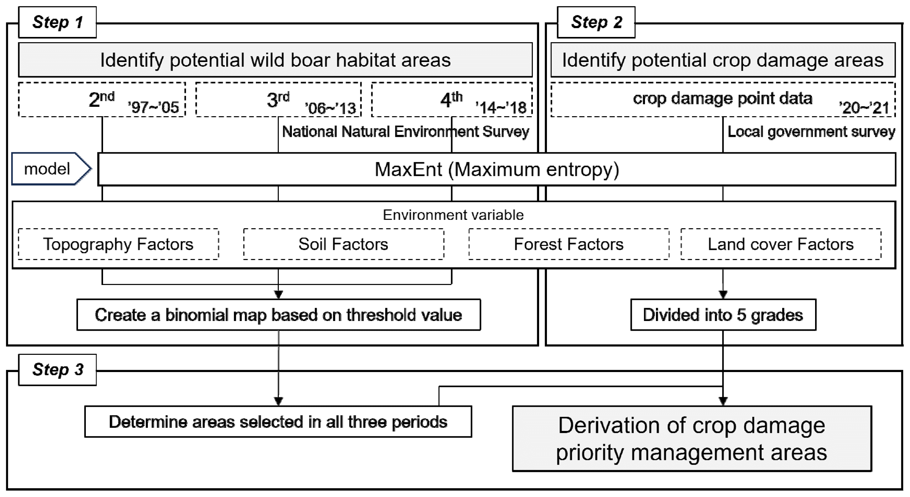
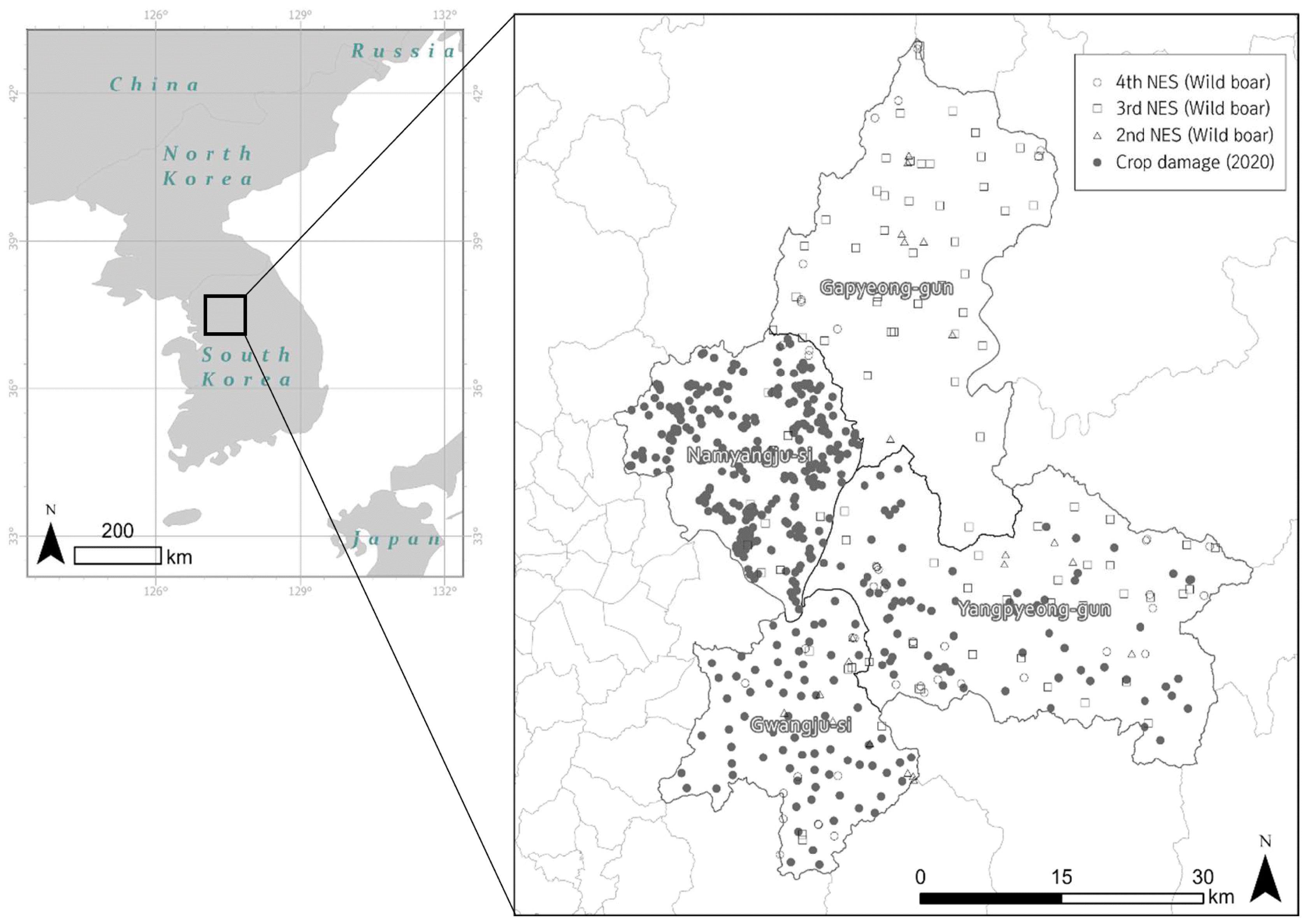
Fig. 3
Maps of potential wild boar habitat derived from MaxEnt models. Panels A–C show results derived from data of respectively the 2nd, 3rd and 4th National Natural Environment Survey periods.
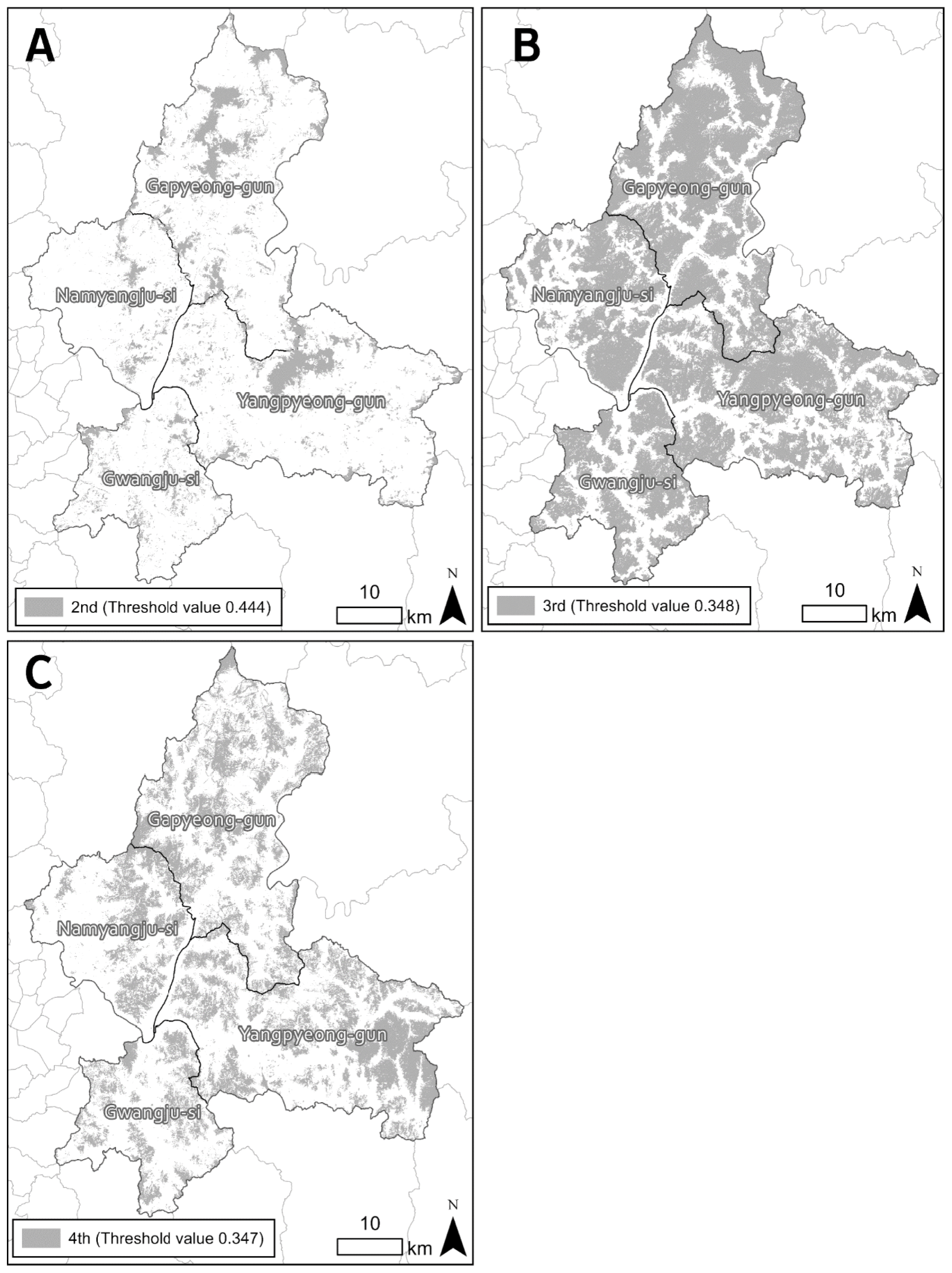

Fig. 5
Comprehensive map of potential wild boar habitats combining data from the 2nd, 3rd, and 4th National Natural Environment Surveys. Habitat areas are shaded based on the number of surveys (0–3) in which they were considered wild boar habitat.

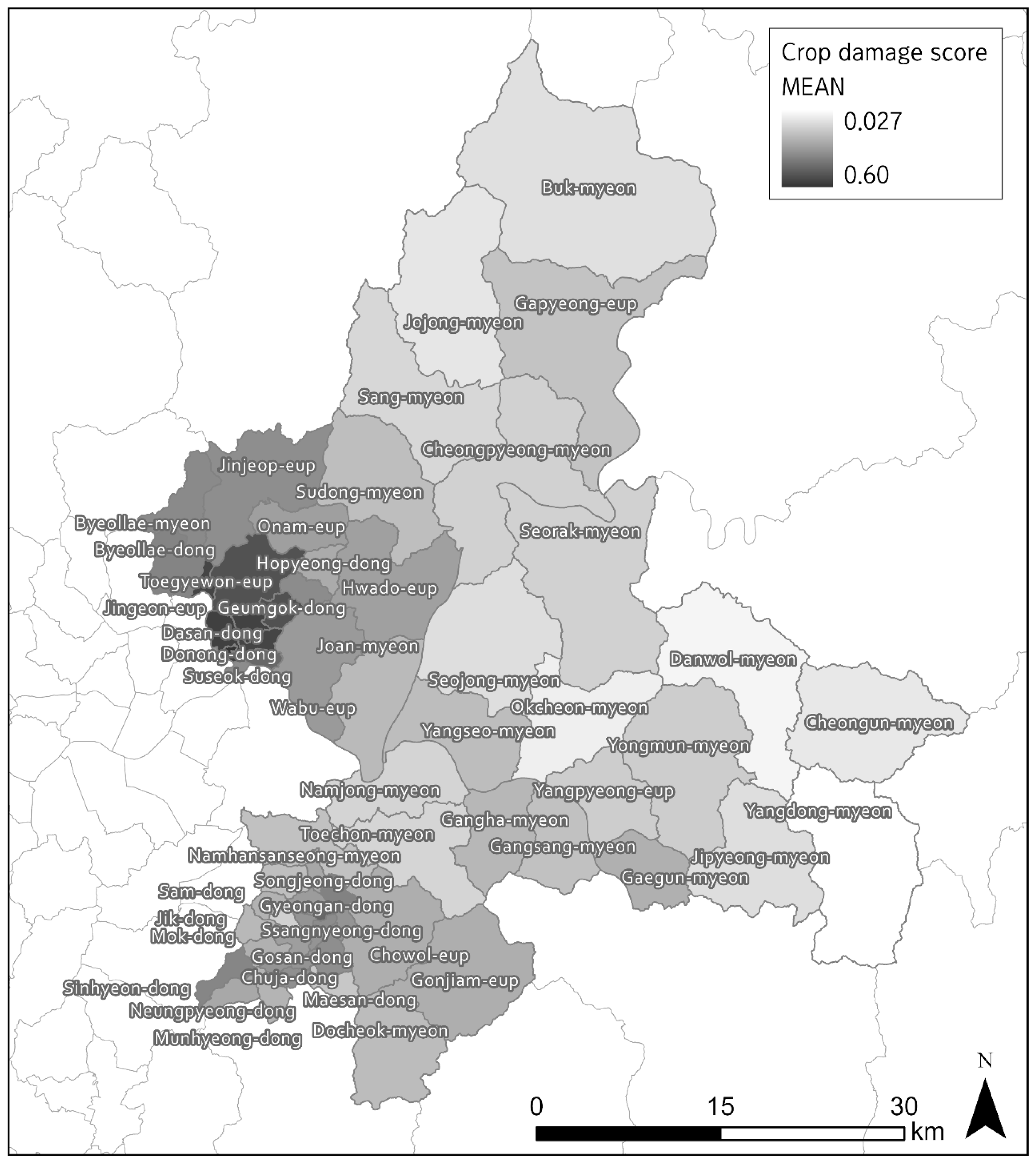
Table 1
List of environmental variables affecting wild boar habitation based on prior research
| Class | Environmental variables | Abbreviation | Source |
|---|---|---|---|
| Land cover | Distance from residential/industrial/commercial area | d_urban | Bosch et al., 2020; Allwin et al., 2016; ENETWILD consortium et al., 2019; Lim et al., 2021 |
| Distance from road | d_road | ||
| Distance from paddy field | d_paddy | ||
| Distance from farmland | d_farm | ||
| Distance from orchard | d_orchard | ||
| Distance from river | d_river | ||
| Distance from bare ground | d_bare | ||
| Distance from trail | d_trail | ||
|
|
|||
| Forest | Forest and grassland type | forest_type | Park and Lee, 2003; Bosch et al., 2020; Lee and Lee, 2014; Rho, 2015; Allwin et al., 2016; Lim et al., 2021 |
| Density of forest | density | ||
| Oak tree presence | oak_tree | ||
| Age class | ageclass | ||
|
|
|||
| Topography and geology | Slope | slope | Park and Lee, 2003; Rho, 2015; Allwin et al., 2016 |
| Aspect | aspect | ||
| Soil drainage class | soildrain | ||
Table 2
Environmental variable types and source information. NES, Natural Environmental Survey
Table 3
List of accepted and rejected environmental variables in the distribution models
| Class | Abbreviation | Type | Included variables by model | |
|---|---|---|---|---|
|
|
||||
| Potential habitat | Crop damage prediction | |||
| Land cover | d_urban | Continuous | ○ | ○ |
| d_road | ○ | ○ | ||
| d_paddy | ○ | ○ | ||
| d_farm | ○ | ○ | ||
| d_orchard | ○ | ○ | ||
| d_river | ○ | ○ | ||
| d_bare | × | × | ||
| d_trail | ○ | ○ | ||
|
|
||||
| Forest | forest_type | Categorical | ○ | × |
| density | ○ | × | ||
| oak_tree | ○ | × | ||
| ageclass | × | × | ||
|
|
||||
| Topography and geology | slope | Continuous | ○ | ○ |
| aspect | ○ | ○ | ||
|
|
||||
| soildrain | Categorical | ○ | ○ | |
Table 4
Contributions of environmental variables to the models based on the 2nd, 3rd, and 4th National Natural Environment Surveys
Table 5
Size of areas identified as potential habitat in all three models (3 × habitat area) for each administrative district and its sub-districts
Table 6
Wild boar population densities in areas identified as potential habitat in all three models in each administrative district over the 2011–2019 period
Table 7
Crop damage predictions by administrative districts, showing the top 5 local (eup, myeon, and dong) sub-districts within each district
- REFERENCES
- REFERENCES
References
Ab Lah, N. Z., Z. Yusop, M. Hashim, J. Mohd Salim, S. Numata. 2021. Predicting the Habitat Suitability of Melaleuca cajuputi based on the MaxEnt species distribution model. Forests. 12(11):1449. https://doi.org/Aiding, K., O. Majid, B. Abdolreza. 2017. Landslide susceptibility assessment using maximum entropy model with two different data sampling methods. CATENA. 152:144-162. https://doi.org/10.1016/j.catena.2017.01.010
[Article]Allwin, B., M. G. Jayathangaraj, M. Palanivelrajan, M. Raman. 2015. Enumerating endogenous faecal glucocorticoid metabolites as indicators of stress in wild pigs interfering with agriculture adjoining forest regions correlating with conflict and meteorological factors - A non invasive approach. International Journal of Advanced Multidisciplinary Research. 2(3):63-76.Allwin, B., N. S. Gokarn, S. Vedamanickam, S. Gopal. 2016. The wild pig (Sus scrofa) behavior - A retrospective study. Journal of Dairy, Veterinary and Animal Research. 3(3):115-125. https://doi.org/10.15406/jdvar.2016.03.00083
[Article]Bosch, J., I. Iglesia, M. Martinez, A. D. L. Torre. 2020. Climatic and topographic tolerance limits of wild boar in Eurasia: implications for their expansion. Geography, Environment, Sustainability. 13(1):107-114.Carter, M., P. Jianmin, N. R. Shesh, G. Susan. 2016. ROC-ing along: Evaluation and interpretation of receiver operating characteristic curves. Surgery. 159(6):1638-1645. https://doi.org/10.1016/j.surg.2015.12.029
[Article] [PubMed]Choi, J. Y. 2008. Research on application of GIS to prevent of crop damage caused by wild animals. MS thesis. Kangwon National University, Chuncheon, Korea.Choi, T. Y., Y. S. Lee, C. H. Park. 2006. Home-range of wild boar, Sos scrofa living in the Jirisan National Park, Korea. Journal of Ecology and Environment. 29(3):253-257.Claudia, M., P. A. Szafranska, J. Bogumita, B. Kamil. 2006. Biogeographical variation in the population density of wild boar (Sus scrofa) in western Eurasia. Journal of Biogeography. 33:803-811.ENETWILD consortium, P. Acevedo, S. Croft, G. C. Smith, J. Vicente. 2019. ENETWILD modelling of wild boar distribution and abundance: Initial model output based on hunting data, and update of occurrence-based models. EFSA Supporting Publications. 16(5):1629E. https://doi.org/10.2903/sp.efsa.2019.EN-1629
[Article]GRI. 2020 A study on improvement plan for establishing a farm level ASF control strategies Suwon, Korea. Retrieved from https://www.gri.re.kr/.Kim, S. O., T. S. Kim, H. S. Go, G. S. Jang. 2014. An analysis on aspects of farm lands damaged by the wild boar (Sus scrofa) in Gyeongnam Province, Korea. Journal of the Korea Society of Environmental Restoration Technology. 17(6):17-27. https://doi.org/10.13087/kosert.2014.17.6.17
[Article]Lee, S. M., W. S. Lee. 2014. Diet of the wild boar (Sus scrofa) in agricultural land of Geochang, Gyeongnam Province, Korea. Journal of Korean Society of Forest Science. 103(2):307-312. https://doi.org/10.14578/jkfs.2014.103.2.307
[Article]Li, Y., M. Li, C. Li, Z. Liu. 2020. Optimized maxent model predictions of climate change impacts on the suitable distribution of Cunninghamia lanceolata in China. Forests. 11(3):302.Lim, J. S., V. Timothee, S. I. Park, E. Kim. 2021. Modelling the spatial distribution of ASF-positive wild boar carcasses in South Korea using 2019–2020 national surveillance data. Animals. 11(5):1208. https://doi.org/10.3390/ani11051208
[Article] [PubMed] [PMC]NIBR. 2016 Research on improvement plans for wildlife fact-finding survey (Report No. 11-1480592-001212-01) NIBR; Incheon, Korea. Retrieved from https://www.nibr.go.kr/.KNPS. 2022 Survey on wild boar habitat in national parks to respond to African Swine Fever (ASF) in 2022 NPRI; Wonju, Korea. Retrieved from https://www.knps.or.kr/.Kramer-Schadt, S., J. Niedballa, J. D. Pilgrim, B. Schröder, J. Lindenborn, V. Reinfelder, M. Stillfried, I. Heckmann, A. K. Scharf, et al. 2013. The importance of correcting for sampling bias in MaxEnt species distribution models. Diversity and Distributions. 19(11):1366-1379. https://doi.org/10.1111/ddi.12096
[Article]Park, C. R., Y. S. Lee. 2003. Development of a GIS-based habitat suitability model for wild boar Sus scrofa in the Mt. Baekwoonsan region, Korea. Mammal Study. 28(1):17-21. https://doi.org/10.3106/mammalstudy.28.17
[Article]Pei, K. J. C. 2006. Present status of the Formosan wild boar (Sus scrofa taivanus) in the Kenting National Park, southern Taiwan. Suiform Soundings. 6(1):9-10.Rho, P. H. 2015. Using habitat suitability model for the wild boar (Sus scrofa Linnaeus) to select wildlife passage sites in extensively disturbed temperate forests. Journal of Ecology and Environment. 38(2):163-173. https://doi.org/10.5141/ecoenv.2015.018
[Article]Swets, J. A. 1988. Measuring the accuracy of diagnostic systems. Science. 240(4857):1285-1293.
[PubMed]Takashi, I., K. Naotoshi, S. Takaaki, I. Shiori, S. Masatsugu. 2019. Tourist-wild boar (Sus scrofa) interactions in urban wildlife management. Science Direct. 18:1-10. https://doi.org/10.1016/j.gecco.2019.e00617
[Article]Yackulic, C., B. Chandler, R. Zipkin, E. F. Royle, J. A. Nichols, J. D. Campbell Grant, E. H. S. Veran. 2013. Presence-only modelling using MAXENT: when can we trust the inferences? Methods in Ecology and Evolution. 4(3):236-243.Yoo, Y. J. 2018. A study on the image trend of farmlands by wild boar (Sus scrofa) and their control effect. MS thesis. Yeungnam University, Gyeongsan, Korea.Zhang, K., L. Yao, J. Meng, J. Tao. 2018. Maxent modeling for predicting the potential geographical distribution of two peony species under climate change. Science of the Total Environment. 634:1326-1334. https://doi.org/10.1016/j.scitotenv.2018.04.112
[Article] [PubMed]